As many of you may already know, we are on a quest to hike the classic treks of the world. In recent years we have trekked Patagonia’s ‘W’ and Mt. Fitzroy, Nepal’s Annapurna Circuit, Iceland’s Laugavegur Trail, Mt. Kilimanjaro in Tanzania, the Wonderland Trail around Mount Rainier, Himalayan treks in India and both Machu Picchu and the Cordilleras of Peru. This amazing hiking adventure has allowed us the opportunity to see and experience some of the most beautiful natural places in the world and has been mind-blowing to say the very least. The more we do, the more we want to see!
Click to enlarge photographs and view as a slideshow. They are much better that way!


Last year, we planned to tackle California’s legendary John Muir Trail for our big summer adventure. The JMT tops practically every must-do list and is considered the classic American backpacking trail. At 211 miles, the JMT would be our most epic hiking undertaking yet. Traversing the High Sierras, the John Muir Trail is known for its extreme altitudes, dramatic elevation changes, challenging mountain passes, intense river crossings, week-long food carries and 3+ weeks out on the trail. Yep, the JMT was going to seriously up the ante on all of our hiking experiences thus far. So, to say we were a little apprehensive would be an understatement.

Nevertheless, we were determined, and so we made it a goal to get in good backpacking shape to prepare for the adventure. As in years past, we loaded up our backpacks and hit the forest preserve trails all around the Chicago area religiously every spring weekend. By mid-May we were hiking for up to 16 miles at a time with fully loaded, 40+ pound packs. Our objective was to get used to carrying the weight that we would bear on the JMT and build up our strength and stamina to boot.


Even so, we knew deep down that all of those days of hiking on flat terrain and sleeping in our cozy bed at night would only count for so much. If we really wanted to be prepared for the JMT, a true backpacking trip was in order. A trip where we could gain and lose some serious elevation. A trip where we could sample some of the new high-energy snacks and backpacking meals we were planning for our JMT menu. A trip where we could spend several days on the trail camping out and testing out some of the new lighter weight gear that we had acquired since backpacking the Wonderland Trail in 2014. We needed to get dirty, go without showering, and wear the same pair of underwear for days on end. In short, we needed to get a taste of what the JMT would really be like.
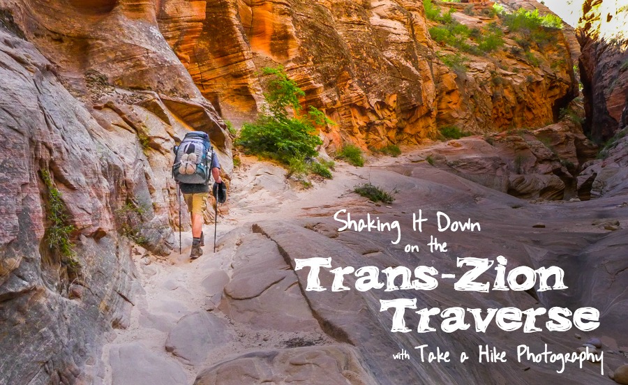
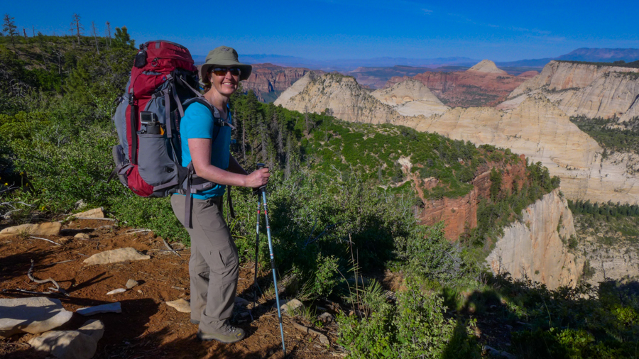
In backpacking lingo, this is known as a “shakedown hike,” and Utah’s Zion National Park offered us the perfect place to do it. In late May, we would take 5 days to hike 48 miles on the Trans-Zion Traverse. We would walk across the entire park from west to east through gorgeous backcountry terrain that most Zion visitors rarely get the chance to see.


Why Hike the Trans-Zion Traverse?
Mention Zion National Park to any outdoor enthusiast or nature photographer, and chances are that they will swoon. Located in the southwest corner of Utah, Zion National Park is geologically blessed with an enchanting desert landscape that visitors can not get enough of. Massive sandstone cliffs, narrow slot canyons, and entrancing desert landscape—what’s not to love, right?

Quite simply, it’s the people. Head into Zion on a spring or summer weekend, and you will be overwhelmed by the masses of visitors who have come to get a look at this incredible park, too. Part of the problem is that most of the park’s A-list sites, including Angels Landing, the Narrows, and the Temple of Sinawava, are located along a winding, narrow road known as the Zion Canyon Scenic Drive that meanders its way along the banks of the Virgin River into the heart of the park.
The concentration of attractions along with a steady rise in the popularity of Zion has led the park service to develop a shuttle system to ferry visitors into the park. From approximately March to November, private cars are not even allowed into the main canyon. Visitors must park at the visitor station or on the street in nearby Springdale. At peak times the lines to board the shuttles can mean long queues and wait times, not to mention crowded trails and over-stressed bathrooms.

Don’t get us wrong, Zion’s main canyon is beautiful. But, if you are hoping to get away from it all and find some solitude (and isn’t that what hiking is all about?), this is definitely not the place for you. If all you’ve seen of the park is Zion Canyon, then you haven’t truly seen the park in all its glory.

Planning Your Route
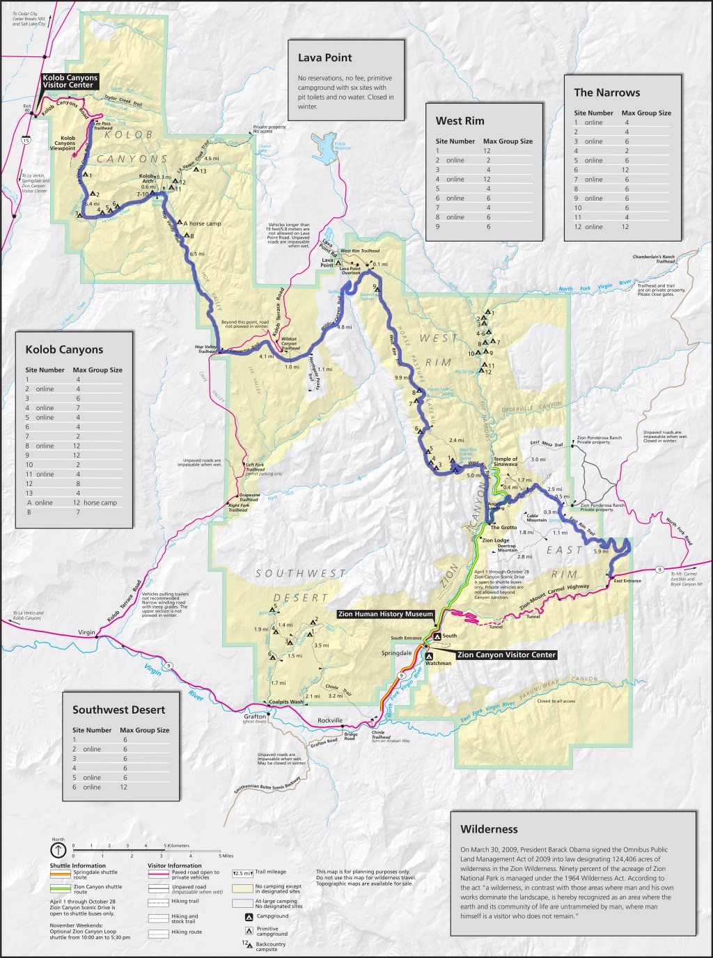
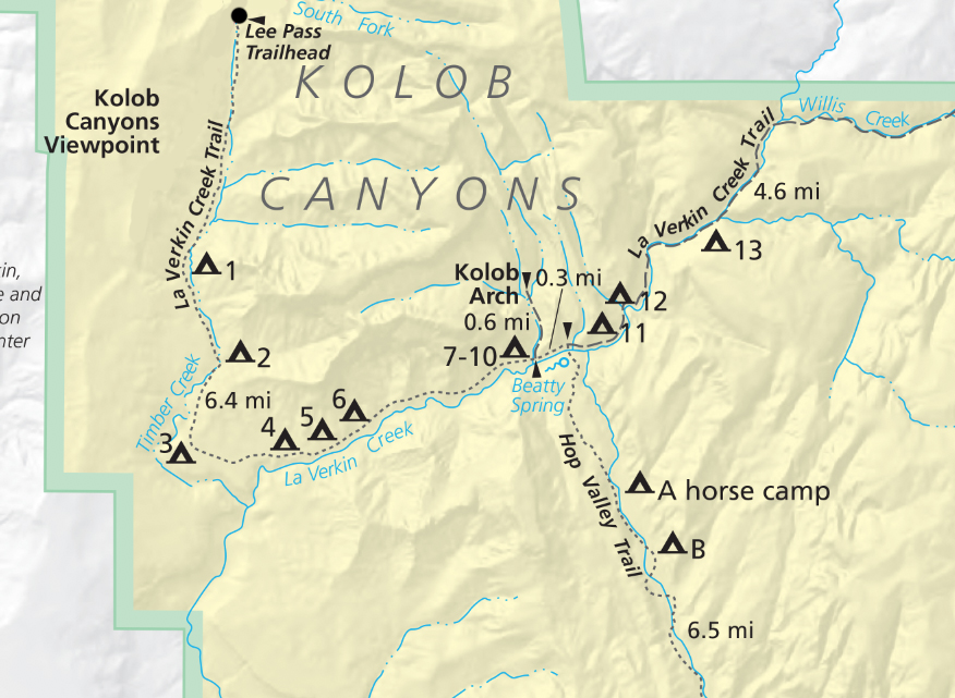
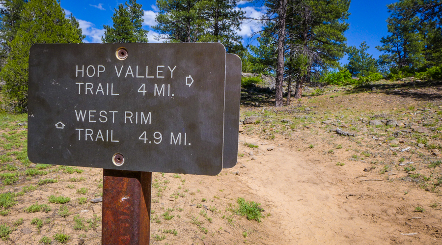
The Trans-Zion Traverse is not a single trail but is instead a combination of trails that span the entirety of the park. When combined together they form a superb 48-mile thru hike. From west to east, these trails include: La Verkin Creek Trail, Hop Valley Trail, Connector Trail, Wildcat Canyon Trail, West Rim Trail, Road Section along Zion Canyon Scenic Drive and, finally, the East Rim Trail.
The Trans-Zion Traverse is a moderately challenging backpack. While it requires no technical skills, such as scaling peaks, fording rivers or crossing snowy passes, the extreme heat of the desert and lack of water will be your primary challenges.
For most of its route, the TZT stays on the plateau above Zion Canyon, and it is a slow and steady climb from either trailhead toward the rim of Zion Canyon. Once you hit the canyon rim, though, all bets are off. The trail drops quickly and steeply to the valley floor. From the West Rim, you are looking at a 2500-foot change in elevation, while it’s a slightly more manageable 1900 feet from the East Rim. Although there is no particular advantage in going one way over the other, the majority of people generally hike the trail from west to east.

Either way, you have to go down one side of Zion Canyon, across the Virgin River on the valley floor, and then straight back up the other side, all in one long day. Most hikers tend to prefer a longer downhill and a shorter uphill and opt to head from west to east. Other advantages of this direction include saving this long, challenging day until closer to the end of the trek rather than the beginning. A west to east route puts you closer to the town of Springdale at trip’s end as well.

Some hikers choose to skip out on the East Rim entirely and catch the park shuttle back to the Visitor Center once they come down the West Rim, cutting off about 12 miles off the trail and one day of hiking and making transportation logistics a tad easier. We found the East Rim side of Zion to be extremely beautiful and definitely recommend including this portion if your time allows.
At 48 miles, most people hike the TZT comfortably in 5 days. How those 5 days map out will vary greatly depending on which campsites you are able to secure in the permit process. The TZT has a combination of designated individual campsites and dispersed backcountry sites. Water sources are very limited along the route, and, due to the fragile desert environment, the park’s designated campsites are few and far between. As a result, your daily mileage on the trail will vary depending on where you are permitted to camp.
Getting a Permit
Before heading out on the Trans-Zion Traverse, you must get a backcountry wilderness permit that allows you to camp along the trail. We were able to reserve our permit in advance through the Zion National Park website, but trust us when we say it was not an easy task. The permit process is extremely competitive, and there are very few backcountry sites to begin with on the TZT. For example, the 14.2 mile West Rim Trail has a total of only 9 campsites!

About two-thirds of the TZT’s designated campsites are reservable in advance, while the other third are available on a first-come, first-served basis, beginning the day prior to your departure. Hikers cue up outside the Visitor Center as early as 2 am to snag these permits, which is definitely not our idea of fun, so try to get your permit ahead of time if possible. Permits become available (at precisely 10:00 am Mountain time) for a given month on the 5th day of the month that is two months prior to your departure. For example, permits for the entire month of May become available online on March 5. Permits for all of June become available on April 5 and so on. Sounds confusing? Well, that’s part of the weed out process! But we are here for you. See the chart below for help.

The permit process was both stressful and frustrating for us. On March 5, we were at the computer and ready to book at exactly 10:00 am, trying to get a site anywhere along the La Verkin Creek Trail for the first night of our trip. We were hoping to start our trek on the Sunday of busy Memorial Day weekend. It seems that the park’s website can barely handle the amount of people applying for campsites at the same time. Each time we tried to select a site, valuable minutes were wasted while the overloaded system “spun” in vain. By the time all was said and done, all the sites were taken, and we were forced to adjust our start date to leave on the next day instead.

Wilderness permits cost a nominal fee ($15/night for 1-2 people). If you are lucky enough to actually get a site on the date that you want, you will be required to pay for each day separately before you know if you can reserve a permit for the following day. On top of that, our trip happened to span two months (the end of May and the beginning of June), so we could not reserve permits for the last two nights of our trek. We had to wait an entire month (until April 5) to attempt to finish booking our trip! We felt compelled to buy our plane tickets before the fares went up any higher, but this meant committing to a flight even before knowing whether or not we were fully permitted for our backpacking trip. What a pain!


Many folks on the trail we spoke to complained of similar experiences when booking their permits, and most who waited for walk-up permits during the busy weekend we were there did not get the optimal route or the length of time desired on the trail. This is what we were able to secure.

With an average daily distance of under 10 miles, backpacking 48 miles over 5 days on the Trans-Zion Traverse may not seem overly challenging. Be aware, however, that the scarcity of camps along the trek and the limited access to fresh water will mean that your actual daily mileage may be significantly more or less than that. As you can see, our daily distances varied quite a bit, making some of our days relatively easy and others quite challenging. Even so,we weren’t complaining. We felt lucky to have backcountry permits at all. Indeed, securing a permit may very well be the toughest challenge of the TZT.


Getting to/from the Trailhead
The Trans-Zion Traverse is a thru-hike, making the logistics of getting to and from the trailhead more difficult than a loop hike. One option is to have two cars and park one at either end of the hike. If this is a possibility for you, be aware that it will take several hours to drive from one end of the park to the other to drop off and retrieve cars both before and after the hike. Another option is to use a shuttle service, and, luckily, there are many available in the Springdale area.

We used Red Rock Shuttle Service. At $60/person, it wasn’t cheap, but it couldn’t have been easier. We reserved the shuttle well in advance and had our driver meet us at 7 am on Day 1 of our hike at the East Rim trailhead where we would ultimately finish our journey. We made sure to hide all valuables out of sight in the car and place our car permit on the driver’s side of the dashboard, so the park rangers would know who the car belonged to and when to expect us back. This provided us with some peace of mind knowing that the rangers would theoretically come looking for us if we did not pick up our car by the exit date indicated on the permit.
We loaded up our gear and made a quick stop at the Zion Canyon Visitor Center to pick up a few other backpackers before driving on to Kolob Canyons Visitor Center at the West Rim Entrance. There, we registered our permit before proceeding on to the Lee Pass Trailhead. By the time all was said and done, it was 11 am before we officially began the Trans-Zion Traverse and the 5-day hike back to our car.
Best Times to Go
Due to extreme temperatures, the hiking season for the Trans-Zion Traverse is relatively short. Winters at this elevation in Utah are cold and snowy, making trail conditions too icy and treacherous to hike safely before April at the earliest. Even in late spring, snow storms are still possible, so it is advisable to pay attention to the weather forecast and check with the park staff about current trail conditions.

By June, temperatures in Zion Canyon routinely exceed 100ºF making it dangerously hot to hike for prolonged periods in the desert. Snow starts falling again as early as October, making May and September the ideal months to hike. Be aware there is very little shade available anywhere along the TZT. Wear protective clothing, plenty of sunscreen, a wide-brimmed hat and sunglasses to protect from the harsh sun.
Water Sources
Access to fresh water is a primary concern on the TZT. There are very few sources along the trail, and sometimes they can dry up. Water flow at many of the sources is monitored remotely. Be sure to check with park staff about current water availability before heading out on the trail. If you are accustomed to filtering water from flowing streams in the wilderness, the TZT will come as quite a shock. Several of the springs are little more than a trickle of water coming out of a pipe or a rock, so allow plenty of time to top up. And, of course, don’t forget to purify your water before drinking.


Many of the campsites on the TZT do not have convenient water sources nearby. You may need to carry more water than you typically do in order to have enough available for drinking and cooking, so be sure to have a means of doing this. In addition to our 3-liter water bladders, we carried some lightweight collapsible water bottles specifically for this purpose. The Park Service recommends drinking a minimum of one gallon of water/person/day while hiking in desert conditions. Backpackers should probably drink more.
Water is available at the following spots along the TZT: La Verkin Creek, Beatty Spring, Wildcat Spring, Sawmill Springs, Potato Hollow, Cabin Springs and Stave Springs. Please note that several of these are seasonal and will dry out before summer. On our trip in late May/early June, only the La Verkin campsites were located at an abundant water source. We cached a 2-gallon jug of water at the Hop Valley Trailhead the day before we set out to guarantee an adequate amount for Day 2. We knew we had a dry camp on Day 3 and had to fill up for the night many miles before arriving at camp. Stave Spring on Day 5 was barely a trickle! Be prepared.
Getting to Zion and Preparing for Your Trek
Zion National Park is located 3 hours from Las Vegas, making it the most convenient airport to fly into if you are coming from farther afield. Car rental is easily available at the airport. All roads in the park are paved so 4WD is unnecessary despite what the rental agencies may try to sell you. Springdale is the gateway town to Zion National Park where you can find numerous restaurants, hotels, grocery stores and outfitters. Be aware that Springdale is a busy, commercial center. Long lines into the park develop quickly in peak season causing traffic jams. Parking spaces fill up quickly.
There are two national park campgrounds located near the Zion Canyon Visitor Center, but spots here fill up fast. Watchman Campground accepts reservations in advance, but South Campground has 117 sites available on a first-come, first-served basis. All sites are typically taken before noon. On the night before we began the TZT, we camped outside the park’s East Entrance at the Ponderosa Ranch Resort which offers a variety of accommodation options to suit any budget. While not exactly a wilderness experience, it was a convenient location for our shuttle pick up at the East Entrance trailhead. There is also plenty of BLM land adjacent to Zion National Park which offers free primitive camping but no services.
Wildlife
Mountain lions and black bears are spotted very rarely in Zion National Park, so this is a great place to go backpacking if the idea of sleeping in a tent among large predators is worrisome to you. Seeing rattlesnakes and coyotes is quite common, although we did not come across either. Most of our wildlife encounters were of the lizard variety, and we also spotted a few exciting birds species, heard some interesting-sounding frogs and saw numerous deer both along the trail and grazing around our camps in the evenings.


Navigation
Navigation on the Trans-Zion Traverse is super simple. Just remember that the TZT is not an official thru-hike, so you will need to follow the signs for the individual trails that you follow along the way. The trails and intersections are well-signed, but be sure to pay particular attention to where you are going at the numerous intersections you encounter. As always, it’s a good idea to carry a detailed map and compass whenever you venture into the wilderness.


Desert Solitude
So, are all the challenges of doing the Trans-Zion Traverse worth it? Absolutely! With 84% of Zion National Park accessible only through the backcountry and a strict limit on the number of people out there, backpacking the TZT is a prime way to experience the diverse landscapes and extreme desert solitude of one of America’s most dramatic parks.


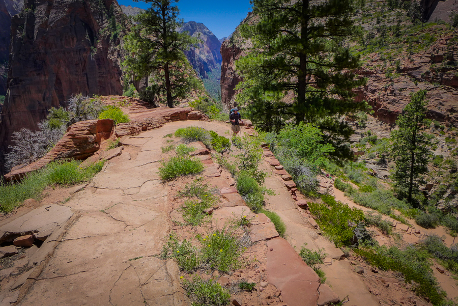
There’s no better way to get to know a park than to hike it from end to end. So come walk with us as we take in the painted rocks of Kolob Canyons, the surprisingly lush plain of Hop Valley, the stunning vistas along the West Rim Trail, the arduous descent down Walter’s Wiggles to the Virgin River and back up Echo Canyon to the East Rim. You won’t be disappointed!
Want more?
Read detailed accounts of each of our days on the trail by clicking on the links below:
Backpacking the Trans-Zion Traverse, Day 1: Lee Pass to La Verkin Creek
Backpacking the Trans-Zion Traverse, Day 2: La Verkin Creek to Wildcat Canyon
Backpacking the Trans-Zion Traverse Day 3: Wildcat Canyon to West Rim Trail
Backpacking the Trans-Zion Traverse, Day 4: West Rim to Echo Canyon
Backpacking the Trans-Zion Traverse, Day 5: Echo Canyon to East Entrance
Pin It:


I hope your entire trekking will be published in book form!
Thanks, Judy! We don’t have any plans to publish our guide to the TZT in a book form, but there will be daily accounts of the trek coming soon. But we do have another book project in the works. Stay tuned for exciting news! 🙂
I was about to say the same thing!
Shucks! I’m not sure this hike is long enough to warrant a book, but we are very flattered. Thank you!
Fun to follow your adventures – great photos make the story come to life.
Thanks – Jamie
Thanks, Jamie! We appreciate you coming along for the ride. Cheers!
This is such a comprehensive post! I cannot even imagine the time and effort that must have went into it! I am bookmarking this post as a benchmark for my future writeups! 😀
Awesome stuff 🙂
Please keep posting!
Thank you! With these hiking guides, we try to cover all the topics that future hikers may have when planning their own trip. If there is anything we left out, please feel free to let us know. They do take a lot of time and effort to create, but we really enjoy sharing our travels with other outdoor enthusiasts like you. Thanks for reading!
Another excellent post. What a great way to see Zion!
Thanks, John! We couldn’t agree more. Hopefully, others will think so, too, and get out of the canyon. There is so much more to see!
I agree with an earlier comment that this could definitely fit well into a guidebook. Such a complete list of all aspects. Add your gorgeous photography and what a guide you have created. As you describe the booking process it too me back many years to the calling in to book the West coast Trail on Vancouver Island. Nerve wracking business and we too needed to adjust the dates once we finally got through.
Thanks, Sue! There’s no book in the works, but, hopefully, people will find our blog a helpful resource. The West Coast Trail is on our Classic Hikes list, too. We have talked to a lot of people who have done it who have said that walk-up permits are pretty easy to get, but things may have changed in recent years. Multi-day hiking trips have become so popular these days! When did you do it? Do you have any recommendations?
We hiked the WCT 15 years ago so unfortunately no current tips. As to walk ins I think if you have some flexibility in dates that could work. I’m such a planner due to vacation restrictions that a booking is required for peace of mind if nothing else. 🙂
Agreed! We would much rather have a permit than not, but we have been lucky with getting walk-in permits on Mount Rainier two times in a row now. But travel days are far too precious to risk having your plans not work out. What are your thoughts on the WCT? Do you recommend doing it?
Absolutely! It was my first big adventure 15 years ago. Compared to the hiking you have done it will seem easy is my guess. At the time it was one of the hardest things I had ever done. So beautiful!
We are not sure exactly when we will get to it, but it’s definitely on the list. Canada is such an amazing country. We can’t wait!!! 🙂
Great reading and absolutely beautiful photos! Thank you for sharing.
Thanks, Monica! We are glad that you enjoyed it! 🙂
Excellent post.Would like to hike with you some day.Cheers.
Thanks! That would be fun. We will let you know the next time we are in your part of the world! 🙂